
Introduction to the Babuyan Islands, just one of the island groups in The Philippine archipelago which is made up of about 7,500 islands, clustered into the three major island groups of Luzon, Visayas, and Mindanao.
From the number of islands, only about 2,000 are inhabited and more than 5,000 islands are yet to be named.
The following series breaks the islands down by region and smaller island groups for easier reference for backpackers visiting the Philippines.
Where are the Babuyan Group of Islands?
 Image courtesy of Wikicommons
Located in the Luzon Strait above the main island of Luzon, this archipelago consists of five major islands and surrounding smaller islands. These main islands are: Babuyan, Calayan, Dalupiri, Fuga, and Camiguin.
The whole archipelago is under the administration of the province of Cagayan with Babuyan, Calayan, Camiguin, and Dalupiri under the municipality of Calayan, while Fuga is under the municipality of Aparri.
The Babuyan Islands are 24 volcanic creations, some of which made up of rugged cliffs and caves, while others are lined with white-sand beaches surrounded by blue, crystal-clear waters.
Babuyan Islands Weather & Climate
The Babuyan Islands is known as a typhoon-battered zone. So unless you’re into extreme adventures, you have to plan your trip carefully and be informed about the months that come under the typhoon season.
The Babuyan Channel is generally too rough for crossings from December to March and during peak typhoon season from August to October.
The best time to visit is from April to June, with April being traditionally the calmest month.
When traveling to the Babuyan Islands, prepare for exposure to the elements and a potentially rough crossing.
Sometimes the weather is unpredictable which may catch you stranded in one of the islands.
A seven-day tour around Babuyan Islands can cost more than $900 or P40,000 per person, which includes all types of transportation, meals for seven days, fees, camping gear and a professional guide – as a backpacker you can do it on around $500 if you bring your own tent with you, its the transport and boat fees that will blow your budget.
1. Babuyan Island or Babuyan Claro Backpackers Guide
One of the islands of Babuyan group of islands is Babuyan Island or sometimes called Babuyan Claro with a population of 1,423 as of the 2010 Census.
Located at the highest and northernmost island in the Babuyan Islands is a volcanic island with a symmetrically-coned shaped volcano known as Mount Babuyan or Smith Volcano which towers at 2,257 feet above and Mount Pangasun or Babuyan Claro Volcano at 3,543 feet.
Both volcanoes have been active in historical time. Since 1652, Smith Volcano erupted six times, the most recent was in 1924.
While the rest of Babuyan Islands have stunning white sand beaches, the beaches of Babuyan Claro have grey to black sand, its terrain heavily forested.
It is possible to visit Babuyan Island without the aid of a travel agency, but it’s better if there was someone who knows the area to guide you where to stay and eat, as well as how to hop from one island to another.
2. Calayan Island – Backpackers Guide
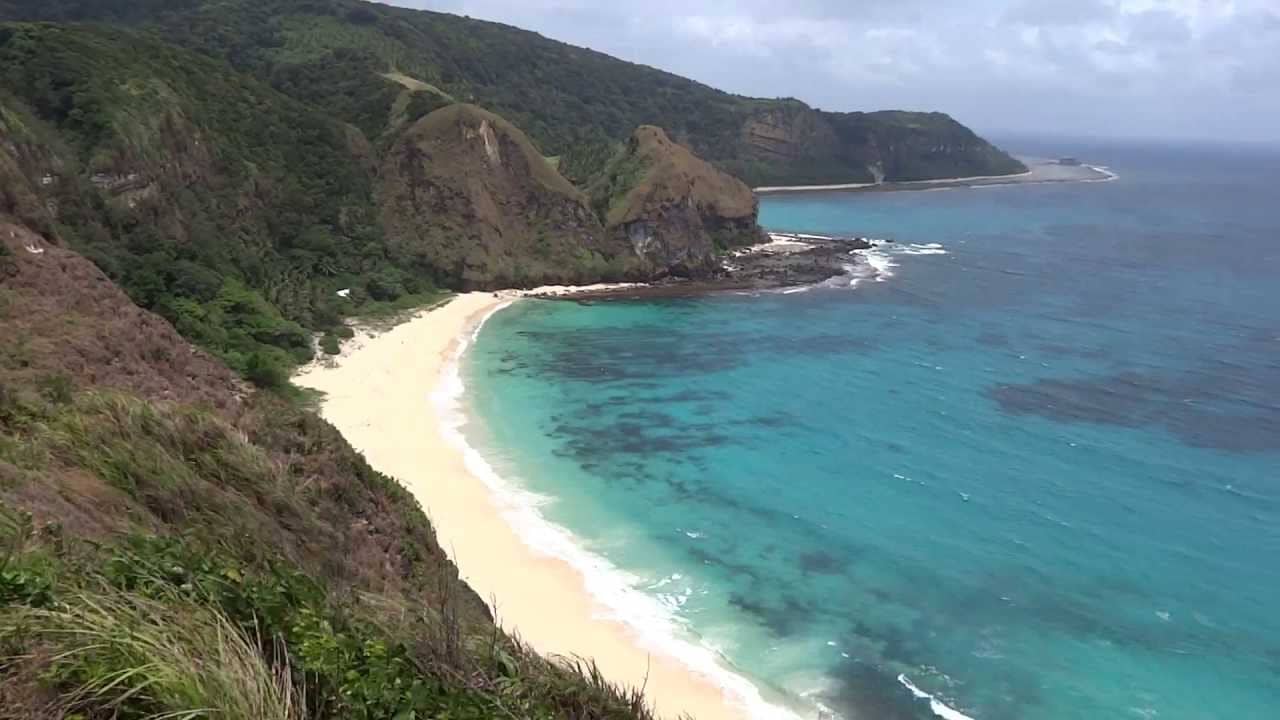 Image courtesy of Youtube
Calayan Island is famous for its white sand beaches, scenic coves, sea caves, and laid back environment.
It is the largest of the Babuyan Islands located in the middle of Aparri and the Batanes group of islands — one of the islands closer to the China Sea on the northern coast of Luzon. Better known as the Babuyanes, the Calayan Islands is comprised by the major islands of Calayan (the municipality center), Babuyan Claro and Camiguin Norte.
Calayan Island is a 3rd class municipality with no airport and no banks, offering visitors a castaway-like getaway. It is where the major settlement is found.
According to the latest census, it has a population of 16,233 people in 2,654 households .Although there are no hotels or proper restaurants in the island but home stays are available and your host can arrange to have your food cooked.
History of Calayan Island
This island municipality is said to have derived its name from an Ybanag word “calayaan” which means “full of ginger.”
In 1616 the first two Dominican Fathers, Fray Andres Sanchez and Fray Geronimo Morer visited the island group. They were followed by other Dominicans however, they did not stay long in Calayan but had managed to convert the islanders into the Catholic faith.
In 1684 a more dedicated missionary ‘Fray Diego Pinero O.P’. was assigned as parish priest of Calayan. He stayed in the island working with the natives helping them with their livelihood.
In 1722, during the Spanish colonial administration, a mission headquarters was established on Calayan Island.
On 11 January 1940, during World War II, American Forces occupied the island. This was welcomed by the people of Calayan as it ushered prosperity to the island.
Schools were established and the American forces also functioned as teachers who also introduced adult education programs.
During World War II on December 1941, the Calayan group of islands were occupied by the Japanese Imperial Forces.
This disturbed the quality of life of the islanders, and many of the development works delivered by the Americans were destroyed. In early 1944 the American Forces reoccupied the islands as part of liberation.
What to do and places to visit on Calayan Island
Calayan Island is accessible from the town of Claveria, Cagayan and Aparri where an outrigger boats depart regularly depending on the number of packages being shipped to and from Calayan Island.
The Coves on Calayan Island
There are three coves — Caniwara, Cababaan and Sibang all located in Barangay Dadao which is approximately four kilometers east from Poblacion.
Sibang/Cibang Cove is a 10-15 minute kuliglig (vehicle composed of a two-wheeled metal cart pulled by a two wheeled tractor) ride and a 30-minute walk away from Centro.
It boasts a strip of fine white sand beach surrounded by limestone cliffs and rock formations. Sibang, which is still undeveloped, offers a true escape for tourists.
Centro Beach on Calayan Island
Centro Beach located in an island laden with colourful wild-flowers and vines and is known as a great spot to view the sunset. It is a perfect destination for swimming, sailing, snorkelling diving, camping, or enjoying a romantic picnic.
The waters surrounding the island is full of various marine life and just couple of yards away, there are huge table-coral formations. The island boasts calm waters all year-round, but still, the best times to visit is during the summer months of March through May, when underwater visibility is more than 50 feet.
Caniwara Cove is surrounded by rock formations and can be reached by hiking or by riding a pump boat from the Centro. Like the Cababaan cove, the unique area is home to a variety of marine life and plants.
Nagudungan Hill on Calayan Island
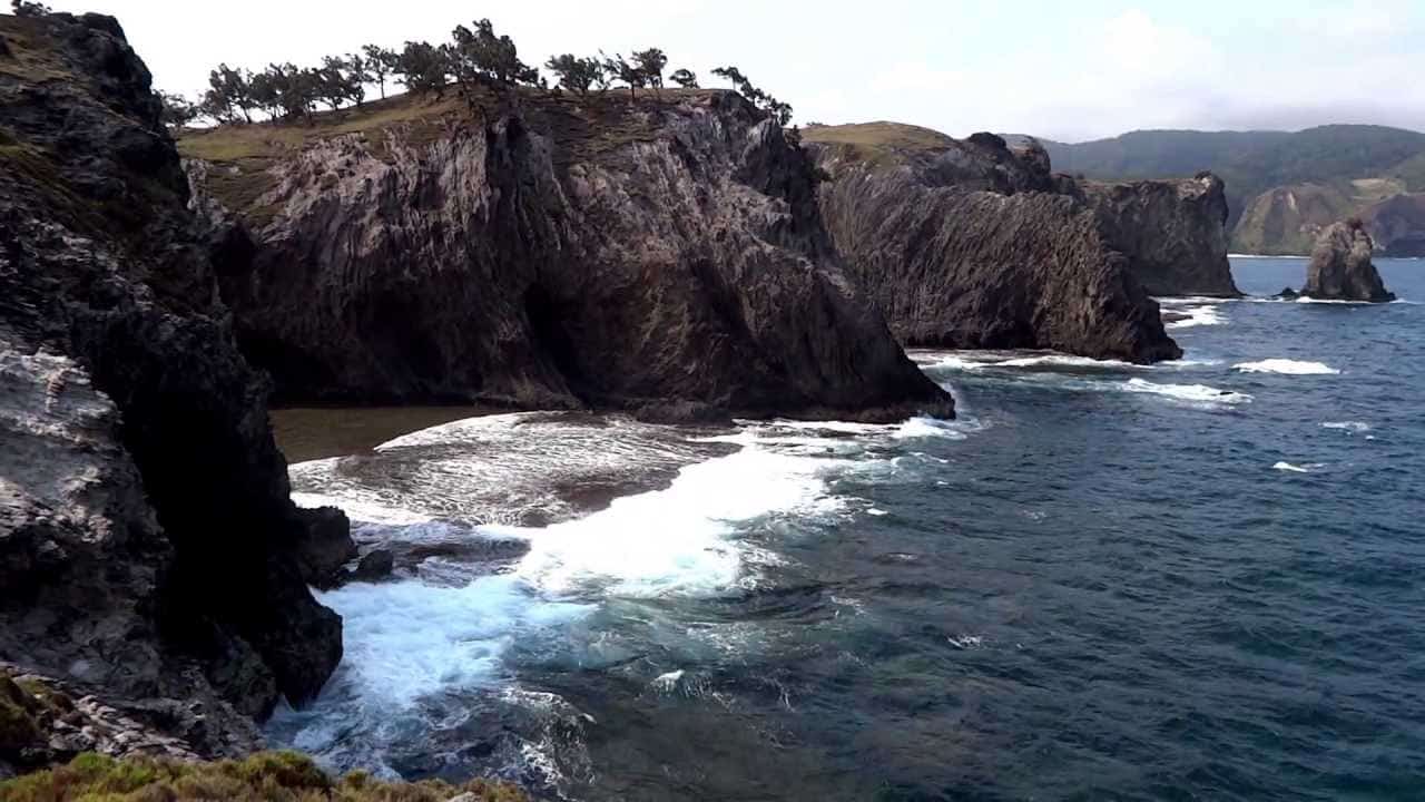 Image courtesy of Youtube
One can see goats and carabaos wandering and grazing in this quiet spot called Nagudungan Hill which is famous for its jaw-dropping cliffs made up of grey-coloured reef limestone rocks and caves.
Known as one of the Philippine’s most scenic seascapes, the hill is a dramatic landscape that dip into the narrow crossing of the Babuyan Channel. Here, one will be able to see various types of birds and eagles circling the sky.
Other places to visit in the Calayan Islands are: Didicas Island, Camiguin Islands where one will be able to see whales and dolphins , Malangsi, Piddan Point, Kumanabang, Lighthouse Near Sibang, Magsidel Punta, Dipari Island in Dilam, Katanapan, Dibay, Puraw, Balagubag, Macara, Banua, Rarasi, and Kaniwalan.
How to get to Calayan Island
One must be brave enough to take on a trip to the Babuyan Islands which is the northernmost point of Luzon. It is as remote as one gets and traveling to get there is an adventure in itself.
From Manila, you can fly to Tuguegarao in Cagayan, or to Laoag City in Ilocos Norte or take a 14-hour bus ride to Claveria or Sta. Ana or Aparri.
The closest municipality to Calayan is Claveria where you can stay overnight in one of the many resorts, hotels or pension houses that cater to all types of budgets.
From the fishing port in Claveria/Lakay lakay port or the Aparri port, take a lampitaw boat ride (motorized pump boat) to Calayan.
If there’s cargo that needs to be shipped and if weather conditions permit, the boats leave between 5 to 7am Boat rides cost P500/person and can last 5-7 hours of roller-coaster boat rides on very rough Pacific Ocean seas.
Another safer option is the M/V Eagly Ferry from San Vicente Port which is also P500. The ride only takes two hours to ply from this port to Camiguin Norte and another two hours to Calayan Island for a total of four hours. This boat is bigger and safer than the lampitaws and can weather the rough sea.
The lampitaw however is a cargo boat and often offers only a few spaces for people. You can also hire a boat from P8,000 – P15,000 depending on the capability of your haggling skills.
Due to unpredictable weather and ocean conditions, your itinerary has to be flexible and also be ready for the possibility of getting stranded on an island for several days, for this reason we suggest all backpackers take a tent.
On the lampitaw there’s a big chance you’ll be exposed under the sun so prepare your sunblock, shades and light coloured long sleeved shirts.
Always bring water for hydration and enough food for the journey. On rare occasions the lampitaw will have to take shelter in Fuga Island or Dalupiri and there might not be enough food.
Also, cover your bags with plastic because the rough seas can get them wet and of course be ready to get soaked as well.
To find out the availability lampitaw, it would be good to have a contact from Calayan who can advise you if there are vessels that will travel to Calayan from your location, a mobile telephone to your friendly local will do the trick.
3. Camiguin Island – Backpackers Guide
An island with the same name as in Mindanao, Camiguin Island, which is within the municipality of Calayan in the province of Cagayan is an island of astounding and unadulterated natural beauty.
It is divided into three barangays, Minabel, Naguilian, and Balatubat with a total population of 4,580. The livelihood of its inhabitants are fishing, farming, fruit tree growing, livestock, and the buying and selling of agricultural products.
The island has five schools from elementary to high school but the students have to go to the mainland of Aparri for their college education.
There are no roads in Camiguin island which makes the motor boat its major means of transportation. There are also no public markets but instead there are some sari-sari stores or small convenience stores.
Health facilities in the island are just are health centers with no doctors and only a few medical supplies and equipment. Instead, people only rely on the resident midwife.
The source of electricity is generators which only run for five hours per day and are limited only to families who can afford to pay for them.
4. Dalupiri Island Backpackers Guide
Dalupiri Island makes up the barangay of Dalupiri, which is part of the municipality of Calayan in Cagayan province.
It can reached by boat from the Port of Aparri. Its terrain is basically flat with a few gentle slopes and has a 2.5-kilometer river called Manalong that runs across it.
The island is rich in vegetation and the people, which only numbered 606 in 2007, thrive on farming and raising farm animals such as carabaos, horses, cows, and pigs.
The island is also a temporary home to migratory birds as well as exotic wildlife including the nankeen night heron, zebra ralle and a dwindling number of Philippine crocodiles.
5. Fuga Island Backpackers Guide
During the Spanish period, Fuga Island was owned by the Dominican Order and was eventually returned to the Filipinos after the signing of The Treaty of Paris. Today it is privately owned by Fuga Island Holdings.
Among the Babuyan islands, it is the only island that belongs to the town of Aparri.
The island is known for the 626-feet Mount Nanguringan, the highest mountain in the island and is famous for paradise-like its crystal blue waters which is a haven for scuba divers, it also offers great day and night trekking, and is a good place to hunt out coconut crabs and spot deer.
According to the 2000 population census, Fuga island has 1,786 people mostly living in the Naguilian (Musa) village on the southern coast.
The island still retains an annual traditional culture of constructing a small straw imitation boat that is floated out to sea. The origin of this tradition began in 1656 when the island was almost invaded by British ships.
At that time, the islanders thought of building a replica of a boat made of light materials to fool the British which eventually prevented the island from being conquered.
In 2014 it was reported that an anonymous American billionaire paid a mind-blowing US $2 billion for a 25-year lease of this picturesque and very private island.
Helpful articles and blog posts on the Babuyan group of islands in the Philippines
We only recommend writers and blogs that we read regularly and believe will deliver substantial value to our readers. The following is our top picks of articles on the islands of Babuyan in the Philippines that we think are worth reading:
- Cagayan Travel Blog: Stranded in Paradise – Calayan Island, Babuyan Islands by Akrosdayunibers
- Babuyan Island Attractions: What to do and suggested places to visit in Calayan by Juanderfulpinoy
- Calayan Island: Caniwara, Sibang & Cababaan Coves by Eazytraveler
- Views of Balintang Island, Babuyan Island, Calayan Island, Dalupiri Island and Fuga Island by Jibraelangel
- Travel Guide: Calayan Island, Cagayan by traveling-up
Do you have an awesome link to a relevant well written article that should be included here? If so, hit us up on Twitter by following and messaging us the link. Looking for the best budget stays in the Philippines? Check out our guide to the Philippines for further information.
How Did We Do?
Is the article “The Babuyan Islands – Backpackers Guide to The Philippines” useful? If so, please share and like this post, as it helps other travelers find information. Many thanks! You can follow us on Twitter or Facebook for further updates!